Log in
All resources
Create a design
9,296 Free Artworks of Map Collection
bibliothèque nationale de france
carte de moscovie by guillaume de l'isle (1706)
national library of poland
oil on canvas
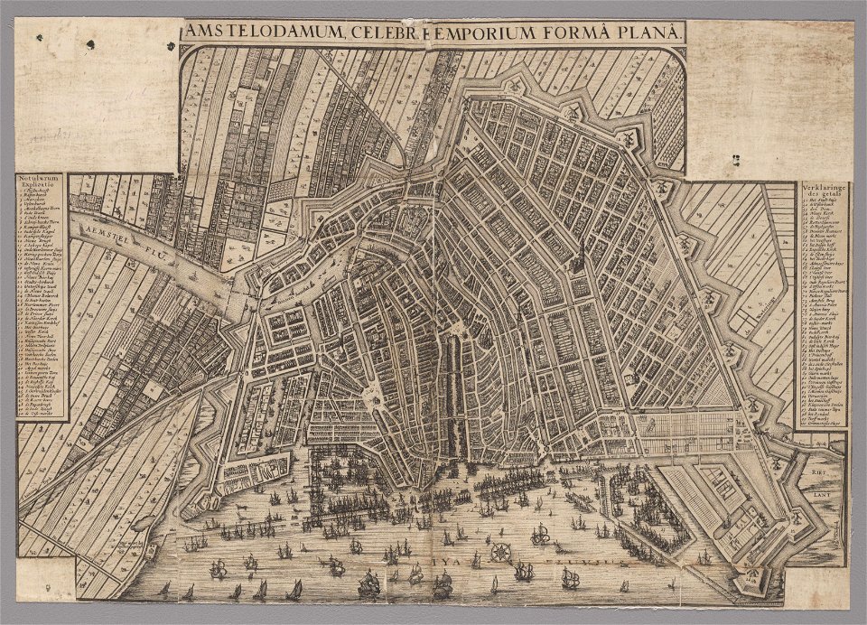
maps in the stadsarchief amsterdam
maps by willem and johannes blaeu
high renaissance,renaissance
drawings by leonardo da vinci in the royal collection of the united kingdom
leonardo da vinci
führer durch dalmatien (1899)
19th-century portrait paintings in the musée national du château de versailles
jean alaux
map of ghent by lucas de heere
collections of archief gent
maps in the stadsarchief amsterdam
claes jansz. visscher (ii)
maps in the stadsarchief amsterdam
hendrik de leth
maps in the stadsarchief amsterdam
hendrik de leth
maps in the stadsarchief amsterdam
hendrik de leth
drawings by pieter jansz. saenredam in the beeldcollectie van de gemeente haarlem
siege of haarlem
maps of alsace, breisgau and sundgau by gerardus mercator
maps by willem and johannes blaeu
17th-century maps of the isle of man
maps by willem and johannes blaeu
maps of chomutov by braun & hogenberg
maps of čáslav by braun & hogenberg
1630s maps of the americas
maps by jodocus hondius ii
veteris novae que urbis amstelodamensis ichnographia, continens publica aedificia ; veterem subnigrioribus... delineata auctore d. stalpaert - btv1b53212660h
bibliothèque nationale de france
maps of chomutov by braun & hogenberg
maps of čáslav by braun & hogenberg
map collection of leibniz-institut für länderkunde
1750s maps of saxony
maps of the islands of greece by marco boschini (1658)
old maps of symi
veteris novae que urbis amstelodamensis ichnographia, continens publica aedificia ; veterem subnigrioribus... delineata auctore d. stalpaert - btv1b53212660h
bibliothèque nationale de france
map collection of leibniz-institut für länderkunde
1680s maps of the netherlands
maps by willem and johannes blaeu
1640s maps of scotland
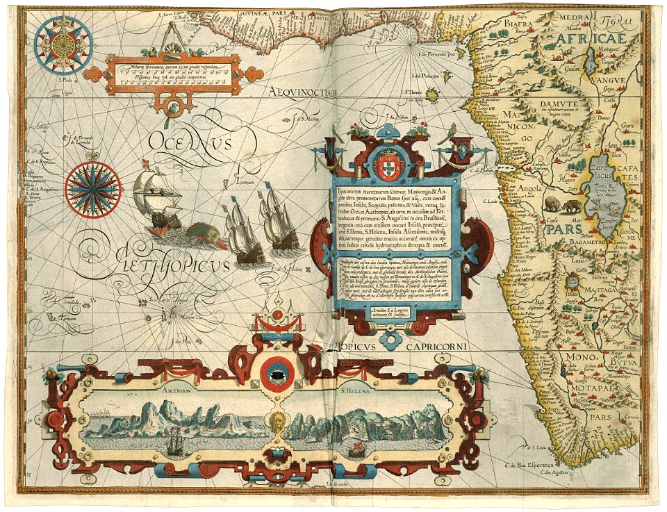
arnold van langren map of southwest africa
renaissance
maps of wallachia by gerardus mercator
maps by willem and johannes blaeu
maps of windsor by braun & hogenberg
maps of oxford by braun & hogenberg
maps of cambridge by braun & hogenberg
bibliothèque nationale de france
florence in the 1470s
pianta della catena
drawings by leonardo da vinci in the royal collection of the united kingdom
high renaissance,renaissance
the empress maria theresa and her family - riesensaal, hofburg, innsbruck (series by the circle of meytens)
portrait paintings of prince albert of saxony, duke of teschen
maps of amersfoort by braun & hogenberg
atlas de wit 1698
maps of 's-hertogenbosch by braun & hogenberg
frederick de wit
chorographia britanniae (1741-1742)
18th-century maps of lancashire
genre paintings by gerard ter borch (ii)
baroque
carte de moscovie by guillaume de l'isle (1706)
bibliothèque nationale de france
the bottom of the sea (1870)
distance
carte de moscovie by guillaume de l'isle (1706)
bibliothèque nationale de france
carte de moscovie by guillaume de l'isle (1706)
bibliothèque nationale de france
carte de moscovie by guillaume de l'isle (1706)
bibliothèque nationale de france
bibliothèque nationale de france
cartouches by tomas lópez
carte de moscovie by guillaume de l'isle (1706)
bibliothèque nationale de france
carte de moscovie by guillaume de l'isle (1706)
bibliothèque nationale de france
carte de moscovie by guillaume de l'isle (1706)
bibliothèque nationale de france
glaciers and glaciation (1910)
maps of glaciers of alaska
charts and maps of the royal museums greenwich
german renaissance
pierre alexander tardieu
pierre gilles chanlaire
18th-century double hemisphere world maps
1760s maps of the world
les monts pyrénées, où sont remarques les passages de france en espagne dressé sur les mémoires les plus nouveaux - par le sr. sanson... - btv1b532269750
1688 maps of europe
cornell: persuasive cartography: the pj mode collection
franco-prussian war in art
eran laor cartographic collection
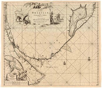
maps of brazil by hendrik hondius
maps of ceuta by braun & hogenberg
ceuta
maps of acquapendente by braun & hogenberg
acquapendente
führer durch dalmatien (1899)
women of croatia by decade
hercules (heracles) in statues
führer durch dalmatien (1899)
führer durch dalmatien (1899)
trau
gaspar miguel de berrío
maps of potosí, bolivia
flora from the british library mechanical curator collection
the cruise of the marchesa (1889)
flora from the british library mechanical curator collection
the cruise of the marchesa (1889)
atlas ou representation du monde universel t. 2 (1633)
nicolaes visscher i
maps of the islands of greece by marco boschini (1658)
old maps of dipso, crusia, tragia, forni, mandria
carte de la mer méditerranée en trois feuilles (dheulland et al.)
18th-century maps of the eastern mediterranean
maps of the islands of greece by marco boschini (1658)
old maps of the lesser cyclades
carte de la mer méditerranée en trois feuilles (dheulland et al.)
old maps of the central mediterranean
sanson maps of the circles of germany
1670s maps of baden-württemberg
carte de la mer méditerranée en trois feuilles (dheulland et al.)
18th-century maps of the western mediterranean
1667 map of madagascar by guillaume sanson
bibliothèque nationale de france
maps of agnano and grotta del cane by braun & hogenberg
context files from gallica
carte de la mer méditerranée en trois feuilles (dheulland et al.)
old maps of the central mediterranean
church exteriors in sweden
vrigstads rivna kyrka
views of oslo from ekeberg
franz šedivý
utagawa school,kasei culture,ukiyo-e
ndl-dc 1307521 tōto meisho zu
18th-century maps of the bosphorus
joseph roux
civitates orbis terrarum. de praecipuis totius universi urbibus. liber secundus
maps of orléans by joris hoefnagel
18th-century maps of the indian ocean
guillaume dheulland
carte de barbarie, nigritie, guinée par guillaume delisle (1707)
eran laor cartographic collection
italia - di matteo greuter... - btv1b525056959
old maps of dalmatia
the elisha whittelsey collection
gerard groenning
media contributed by university of illinois urbana-champaign university library
maps of guinea by mercator-hondius
drawings by leonardo da vinci in the royal collection of the united kingdom
high renaissance,renaissance
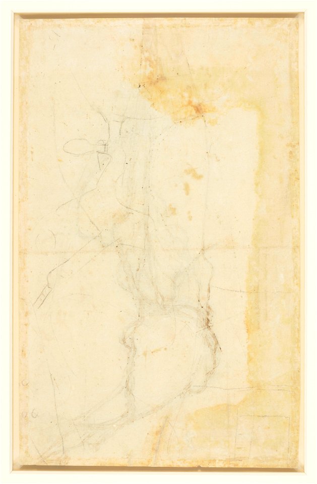
drawings by leonardo da vinci in the royal collection of the united kingdom
high renaissance,renaissance
drawings by leonardo da vinci in the royal collection of the united kingdom
high renaissance,renaissance
anthonisz., cornelis - gezicht op amsterdam in vogelvlucht - amsterdam museum
oil on panel
william i of the netherlands (joseph paelinck - rijksmuseum amsterdam)
1819 portrait paintings of men
map of the circle of austria by sanson
bibliothèque nationale de france
bird's eye view maps of virginia
charles magnus
maps in the staats- und universitätsbibliothek hamburg
baroque
fashion and costumes from the british library mechanical curator collection
arnold henry savage landor
maps of bernkastel-kues by braun & hogenberg
steinfels collection
1596 maps of africa
renaissance
paintings in the sonderauftrag linz
carl seiler
guillaume guillon lethière
neoclassicism
paintings in the sonderauftrag linz
friedrich friedländer
patrimonium 2 (project)
victorian architecture
patrimonium 2 (project)
victorian architecture
führer durch dalmatien (1899)
kotor cathedral
nypl collection of atlases, gazetteers, guidebooks and other books
nypl lionel pincus and princess firyal map division
acta eruditorum - maps
1687 engravings
croppings from pianta di roma (pérac-lafréry)
media from accademia delle scienze di torino
media from accademia delle scienze di torino
renaissance
dutch 17th-century prints in the rijksmuseum amsterdam
maps in the rijksmuseum amsterdam
battles of lexington and concord
amos doolittle
jean-baptiste mallet
medici venus in art
atlas maior, vol 2 (sweden, russia, poland, eastern europe, and greece) - joan blaeu, 1667 - bl 114.h(star).2
copper engraving print
atlas maior, vol 2 (sweden, russia, poland, eastern europe, and greece) - joan blaeu, 1667 - bl 114.h(star).2
copper engraving print
atlas maior, vol 3 (germany) - joan blaeu, 1667 - bl 114.h(star).3
copper engraving print
5901 - 6000 of 9,296
Next page
/ 93